Archive for the ‘Metro’ Category

Transit Expansion

October 28, 2009

Photo by matthewbradley

Streetcars

We’ve got more details on DC’s streetcar plans.  BeyondDC has more details on the plans (at BDC/GGW), and Yonah Freemark chimes in with comments at the transport politic.

And, just for fun, this is a great reason to link to the old map of DC’s streetcar system circa 1958 (matching many of DDOT’s historical photos).

Metro Extensions

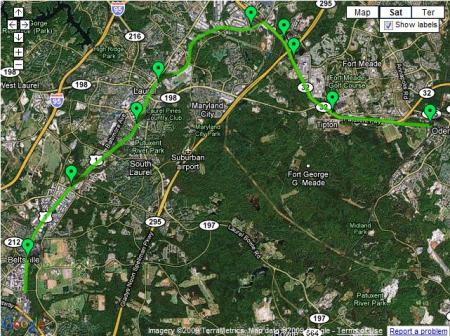
In other transit expansion news, Prince George’s County is working on re-doing their transportation plan.  One of the ideas thrown out so far is an extension of the Green Line from Greenbelt through to Laurel:

The county also wants the Green Line extended from Greenbelt to Fort Meade by way of Beltsville and Laurel. The stops could include Konterra, a massive mixed-use development underway at the eastern end of the ICC.

GGW’s summary on these developments also links back to previous posts on the plan’s highway and transit components.  Dave Murphy, however, takes the Green Line extension idea and improves upon it – by diverting the Metro extension away from the CSX/MARC Camden line tracks though Fort Meade (which is already a huge employment center and set to grow even more with various BRAC relocations) before terminating at Odenton – also connecting with the MARC Penn Line.

GreenLineExtMap

The idea of serving Fort Meade is good – it needs more transit service to meet growing demand.  Likewise, the idea of connecting both MARC lines together through Fort Meade is also good.  The problem, however, is that Metro isn’t the best tool to accomplish this task.  It’s the most expensive mode of transit we have in this region – and should be reserved for the highest capacity, highest potential routes.

The desire to extend Metro rather than invest in other modes is understandable – everyone wants the best.  However, in this case, a massive upgrade of MARC service would be more appropriate and cost-effective – expanding service days and hours, increasing frequencies, offering through-routing to Virginia, and so on.  This site has the advantage of MARC lines on both sides.  If service levels could be increased to match those on some of the Metro-North commuter lines (10-20 minute peak hour headways, late night service, weekend service), extending the Metro wouldn’t be needed.  In the comments of the GGW article, BeyondDC provides an alternate proposal – increasing MARC service while building a cross-“town” light rail line to provide service through Fort Meade.

These kinds of ideas, whether they’re fantasy maps or some other proposal, always generate a lot of interest.  Matt Yglesias offers his thoughts:

Here I think the key thing to keep in mind is that when you’re talking about new heavy rail construction, the potential benefits can be quite large but you have to decide if you actually want to seize them.

If you added a Metro station there, would the local area permit the surrounding quarter mile or so developed as a fairly dense walkable community? Or would people hear about proposals to build on the green space and up-zone the built-up area and decide that would lead to too much traffic? Maybe instead they’ll want to just turn the undeveloped patch into another parking lot. That’d be no good. And the existing land use patterns around Maryland’s Green Line stations don’t inspire a ton of confidence.

Of course, it’s much easier to create an urban environment in an urban setting – plus, you can create the same kind of TOD/urbanism with a heavily accentuated MARC service.

Ryan Avent also chimes in at The Bellows:

To expand on this a little bit, Metro is the region’s most expensive transit option, but it’s also the one with the greatest potential to drive development. Generally speaking, we want to plan our transit systems so that we’re maximizing the benefits we get for the cost of the investment. If Maryland isn’t prepared to zone for significant development around Metro stations, it would be very silly to make the large investment in Metro. Better to develop a commuter rail line or light rail line or both (depending on anticipated development and commuting patterns).

Metro can indeed help shape development, but it’s important to realize that Laurel is still Laurel – no matter how you slice it, it’s a long ways away from downtown DC.

The Silver Line, to take another example, is an expensive investment. It would probably have been much smarter to simply connect Fairfax County destinations (and Dulles) with Arlington and the District via commuter rail but for the fact that the new Metro line is part of a major effort to increase density at Tysons corner.

The key difference between a Green line extension and the Silver line, however, is that the Green line already parallels an existing transitway with huge potential to upgrade service on the cheap (relatively speaking).  The Silver line doesn’t have a similar option – Commuter Rail beyond Tysons Corner would indeed be a great option in the abstract, but the conditions don’t exist to make it work.

Avent’s conclusion is spot on, however.  Extending Metro further out along the Green line is a mis-match between location and mode, and these kinds of mis-matches will impose costs on the core.  Instead of a Parisian system where the Metro and RER compliment each other, Metro’s hybrid nature pushes these two uses into the same system.

These costs are increasingly borne by users in the core of the system, where growth in the number of trains and passengers have led to crowded conditions on platforms and back-ups during peak periods. To some extent, this can be addressed by increasing peak fares, but given the obvious value of Metro, the growth in the system’s spokes, and the fact that the District is better suited than almost anywhere else in the metro area to handle increased density, it seems clear that new core capacity is needed (as well as a new river crossing over or under the Potomac).

Metro doesn’t stop running when it enters the District. If Virginia and Maryland want to continue to build Metro extensions, they ought to offer their full support to an effort to add capacity in the core.

What’s more – investments in the core (say, in the form of a new, separated Blue line) will bear fruit for lines outside the core as well.  The new Blue line would eliminate the capacity constraints of the interlined portion of track through DC – thus increasing the potential capacity on existing Orange and Blue line track in MD and VA.

Express yourself

October 18, 2009

Express subway service is one of those burrs in the saddle for DC folks measuring themselves and their city against New York.

Over the past week, there’s been a lot of talk about express train service.  First, in a GGW point/counterpoint, posters weighed the merits of the current Silver Line proposal versus a hypothetical line along the W&OD trail; Matt Johnson noted the technical hurdles of re-using the W&OD right of way; Dan Malouf/BDC proposed running express train service with the currently planned trackage; Steve Offut looked at using the Route 7 corridor for a new transit line, one that mirrors the general path of the W&OD trail.

All of these discussions about express train service begin from the starting assumption that express service is necessary.  On Friday, Matt Johnson provided some much-needed historical perspective.  The takeaway from his post is that express tracks are 1) quite rare in the grand scheme of things, and 2) are only found in much older legacy systems.

Given that, had planners pressed for a four-track system, Metro would either be half the size it is today, would have taken twice as long to build, or would have been killed outright. The debate we’re having with the Tysons/Dulles Silver Line right now is case-in-point. Already the project has been sliced and diced in terms of frill, and it’s still uncertain whether it will ever reach the airport. The first phase dangled right on the cusp of being too expensive for FTA’s criteria, and several times the project looked all but dead. If things like redundant elevators and the familiar hexagonal tiles might be enough to kill the project, can you imagine the reaction of FTA if Virginia demanded four tracks?

These older, legacy systems were built in a different era of construction standards for disruption and process – New York’s massive cut and cover subways come to mind.

With that note, Second Ave Sagas throws in their two cents.  While New York is constantly cited as a system that’s done it ‘right,’ the Second Avenue Subway doesn’t have express tracks in the works.

The real problem though will come in the future. What will we do when trains break down and hold up the line? What will we do when express service is needed because the local trains are at capacity? The untenable solution would be to construct a time machine and convince New York to build this subway system in the 1930s or 1940s or 1950s when the four-track option was on the table. For now, we’ll just have to live with a two-track line if and when it opens.

One commenter also notes that New York’s subway has lots of express tracks in Brooklyn and The Bronx that are unused – ridership doesn’t warrant express service.   Four-tracked lines are extremely rare in the world for a reason – they’re very expensive and usually not cost-effective.  New York’s express trains are also aided by the very close station spacing for local trains, giving express trains an advantage.  However, when dealing with limited resources, using rapid transit with slightly longer station spacing (as is planned for the Second Ave Subway, and as Metro and most modern systems have been built) is a far more prudent use of funds:

Transit watchers were not pleased with the lack of express service. Considering the length of the route and its projected ridership — around 200,000 per day for just Phase I and 500,000 per day for the entire line — Second Ave. was ripe for an express line. Instead, the MTA altered the spacing of the stations and lengthened mezzanine station access to better serve neighborhoods. The 72nd St. station, for example, will have an entrance between 74th and 75th Sts. while the 86th St. station will have a southern egress between 83rd and 84th Sts. Thus, a station stop at 79th St. was deemed to be unnecessarily redundant.

Instead of pushing for the pipe dream of express tracks, we should push for more investment in the core.  That’s the redundancy we want from Metro.

DC’s potential express tracks already exist – they just have freight trains running on them right now.  A massive improvement in MARC and VRE, getting headways up and extending hours of operations, as well as through-routing, would be a de-facto regional express companion to Metro.

Bottom line – express tracks would be nice, but given the choice between, say, express tracks vs. a separated Blue line, you go for the Blue line, no questions asked.  If tunnel boring machines make it economical to bore a 4-track tunnel, then let’s consider it.   Until then, the marginal improvements in service aren’t worth the added cost.

Metro track work

October 13, 2009

This past weekend’s extensive track work has come and gone.  I was riding the system through L’Enfant Plaza on Monday, and caught a few images from the work.

065-1

Yellow line to Stadium-Armory.

064

Track work equipment under the northern mezzanine of L’Enfant Plaza’s upper level.  Directly behind me was a flatbed car full of old switch tracks that were being removed/replaced from the crossover here.   I tried to grab a photo of that as well, but my camera died.

And, completely unrelated to this weekend’s specific work, escalator reconstruction at Potomac Ave:

066

America’s Metro

October 12, 2009

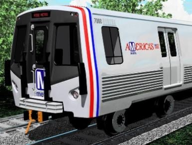
2008_0109_newmetro1

Last week, GGW’s daily links thread noted Metro’s consideration of moving to automated station announcements within trains, instead of the current announcements made by train operators.  The link included a look back to when Metro’s 7000 series railcars were first announced, more than a year and a half ago.

Automated announcements are one of those things that make it easy for those unfamiliar with the system to navigate it.   I can’t think of anyone saying this would be a bad thing, but it certainly removes a bit of the local flavor from the system.  DCist noted this last January, when the new car designs were initially revealed:

  • Automated station announcements. So no more “Judishuwary Square”.

This kind of local flavor is a small sacrifice in favor of greatly improved usability for most riders.  The more troubling aspect of the new car design, however, isn’t the loss of local character, but the bizarre rejection of Metro’s local connections.

As borne out by the DCist comments, perhaps the single most objectionable piece of the 7000 series design was the addition of the new “America’s Metro” logo.  Some see it as an egregious example of poor graphic design (and it is).  More troubling, however, is the fact that Metro is a local asset with a federal role.

Frankly, this isn’t America’s Metro.  It’s DC’s Metro.  Perhaps this logo was an olive branch to the Feds as a means to conjure up support in Congress.  However, the Metro is one of DC’s federal investments that’s paid tremendous dividends to the day to day life of the city’s residents.

The implications for Metro’s identity aren’t too promising, either.  Metro’s always had a strong, modern brand – thanks to the architecture, the unity within the system’s design, and the brand itself.  Since its creation, WMATA hasn’t always been the best steward of that design legacy.  However, the new bus liveries are promising and functional – hopefully this logo will be dropped from the final design for the 7000 series.

Washington Post Newsgraphic on 7000 series

Washington Post Newsgraphic on 7000 series

Technically, the 7000 series should be a welcome addition to Metro’s fleet.  However, let’s not sacrifice the system’s visual integrity.  Thankfully, those seat color schemes have not yet been decided.

These are not minor details, they matter.  Metro has bigger problems these days, to be sure.  That’s no excuse, however, to lower standards.

Cross-posted at Greater Greater Washington

Sorry for the convenience

August 30, 2009

Escalator temporarily stairs!

DCist and GGW note a post from Unsuck DC Metro about old studies on converting some of Metro’s escalators to stairs.  The relevant document is available on WMATA’s website.  As anyone who’s ridden Metro regularly knows, the system has a lot of escalators and they tend to break down quite often.

Zachary Schrag notes in his great history of Metro that escalators were one of the design principles of the system – futuristic, modern stairs.  The original concept wanted to free Metro from the old conceptions of rapid transit, such as the cramped mezzanines and fare gates of legacy systems in New York, Philadelphia, Chicago and others – and one idea was to completely eliminate the mezzanine and deliver passengers directly from the street to the platform.  As it turned out, mezzanines serve a rather useful purpose, so they’re in the design – but the escalators remain.

Despite Metro’s escalator issues (they cost, on average, $51,000 per escalator per year to maintain), they do indeed serve a purpose.  WMATA’s criteria for potential stair replacements only looked at stations with redundancy (i.e. where the removal of an escalator would still leave 2 operational escalators) and relatively short vertical distances (less than 30 feet – which is still a fair hike – three flights of stairs).

DCist doesn’t think those criteria were inclusive enough:

A look at the minutes from the 2006 Customer Service, Operations and Safety Committee meeting finds that Metro could save some $1.2 million in annual operating expenses by replacing escalators with stairs — you know, turning the escalators off — at some 14 Metro stations. Stations with three or more escalators were only to see one set of escalators turned into stairs (but why?), while stations with those 12 kilometer-long escalators like Tenleytown would be unaffected (but why not?).

It’s my understanding that the disabled and the elderly are advised to take Metro’s elevators and to plot their Metro routes by elevator availability whenever using Metro. So the argument that strikes me as the obvious case against stairs is mitigated. On the other hand, stairs promote health and would save the Metro system money. On the other other hand, it seems that at any given time there are a fixed number of Metro escalators that are (broken) stairs anyway.

Actually, WMATA’s criteria make a lot of sense.  First, simply turning the escalators off isn’t a viable option.  The stair heights vary and they’re actually bigger than your usual code-abiding staircase.  Plus, stairs are required to have landings every so often.   Second, that’s not a long term solution.  The shuttered escalators would still require maintenance to ensure that they don’t fall apart.

With regard to replacing those longer escalators, that’s a non-starter.  First, it most definitely would affect ridership if people were forced to walk long distances up stairs.  The shorter vertical distances that WMATA selected don’t have that issue.  Second, due to those landings and step heights, replacing longer escalators is more problematic than short ones.   Notice a station that already has stairs alongside escalators – such as Stadium-Armory – and the staircase ends up in a mini-canyon because of the different rates of rise of staircases and escalators.  For longer distances, this is a bigger problem.

Finally, escalators are faster.  They move people off the platforms faster, and given the relative congestion of many important stations, this cannot be overlooked.  You only need to look at the congestion that can happen at a busy station if the escalator is a temporary staircase for proof that they can move more people through a station faster than a staircase.

It’s too bad that WMATA didn’t act to replace a few of these escalators.  Many of the replacements would have been major improvements not just for WMATA’s bottom line, but also for the circulation patterns within stations.   My ‘home’ station, Potomac Avenue, has three escalators from the mezzanine to the platform.  One was on the list for possible replacements.  On the inbound side of the mezzanine, there are two escalators side by side.  On the outbound side, there’s one escalator and the elevator.  That lone escalator is usually moving in the direction of most commuters – that is, going down to the platform in the morning, and up to the mezzanine in the afternoon.

One annoyance of mine is to get off the train at one end of the platform, only to discover that the escalator there is running in the wrong direction, forcing passengers to walk the length of the platform and go up the other side of the mezzanine.  If that escalator were a staircase, the directionality wouldn’t matter and passenger flow through the station would be more efficient.  Several other stations could benefit from these changes as well.

Smorgasboard

July 17, 2009

Lots of open windows in my Firefox browser, so here’s a link dump:

Beeee-autiful. Dr. Gridlock reports that lots of Metro stations will be getting a nice cleaning over the next couple of months.  He also links to a Post story about the process of cleaning a station from March of this year.  The following stations will be spruced up:

Major Enhancements: Dunn Loring, East Falls Church, Eisenhower Avenue, Forest Glen, Medical Center, Potomac Avenue, Twinbrook, Wheaton, White Flint, U Street, Vienna, West Falls Church.

Mini Enhancements: Ballston, Bethesda, Brookland, Court House, Foggy Bottom, Franconia-Springfield, Friendship Heights, Rockville, Shady Grove, Smithsonian, Virginia Square, Woodley Park.

The enhancements really make a huge difference.  The stations seem lighter and more welcoming.

Freakonomics had a nice post with some links to a few old studies noting how closing roads sometimes improves traffic flow.   This particular case is from Vancouver, but this is precisely the logic behind the pedestrianization of Times Square in New York.  In certain situations, this kind of action can be a win-win-win – you improve traffic flow by simplifying the turning movements and signals, you increase pedestrian space and safety, and you maintain the urban design that makes Times Square an actual square.

The New York Times paints a portrait of the infamous Randal O’Toole.  It’s somewhat sympathetic, but does a decent job of letting O’Toole’s constant obfuscation collapse under its own weight.

The Wash Cycle notes of upcoming efforts to add murals to retaining walls and underpasses along the Met Branch trail.  The Union Station rail corridor – both connecting to the Metropolitan Branch towards Silver Spring and the Northeast Corridor towards Baltimore – is a vital rail link, but also an undeniable barrier in the area.  Public art along some of those underpasses can be a great way to make those links more attractive to cyclists and pedestrians.

With the Metropolitan Branch trail, it’s vital to ensure as many vertical circulation access points as possible – make it easy to shift levels between the trail and the street grid.

Nevertheless, this kind of mural is a great example of an easy public art project that can be a huge asset to the area.

Streetsblog’s DC folks try to document the hierarchy of decision making on the transportation bill. Making a law is always like making sausage, but this particular sausage seems far more complicated than most.  The House folks are fighting a two-front war against both the Administration and the Senate.  That’s a tough road.

You can’t fight in here, this is the War Room!

July 14, 2009

Is Dr. Gridlock actually Dr. Strangelove?  He’s got a post up documenting the hearings going on right now on Capitol Hill, and not the ones dealing with potential Supreme Court justices.  The whole thing is full of colorful Cold War language:

The term entered the common language during the Cold War when Eugene Burdick wrote an arms-race thriller called “Fail-Safe.” The scenario seems dated now: To the stunned surprise of controllers, U.S. nuclear bombers move past the point at which they’re supposed to stop. But it’s still a ripper, because of the well-known principle the 1962 novel illustrated: If something can go wrong, eventually it will. Nothing built by humans is “Fail-Safe.”

The NTSB has already made their hypothesis known – that a glitch in the ATO system allowed the collision, even while operating in automatic mode.   What seems to have happened was a breakdown in the system where there was no redundancy – the failure of one system made it possible for the entire system to fail.

Dr. Gridlock continues with the Cold War imagery:

Metro’s operations control center isn’t as impressive as the Strategic Air Command’s headquarters, with its towering maps and flashing lights, but it’s basically the same function: Redundant protections are supposed to make the train system fail-safe. But ultimately, humans are making sure the equipment is going where it’s supposed to go.

On June 22, a fail-safe system failed to prevent the fatal crash of two Metrorail trains on Washington’s Red Line. And the National Transportation Safety Board told us on Monday that we have no system in place to ensure that this won’t happen again.

On a complete side note, I’ve always envisioned the operations center for Metro or any other large transit system to be like NORAD from WarGames or other Cold War movies.

(NORAD as depicted in WarGames – from PC Museum)

It’s the kind of place where all the super secret information is displayed.  You can’t let outsiders in there because they’ll see the big board!

Given Metro’s stark architecture and generous use of concrete, it’s not hard to envision a Kubrick-esque control room, complete with all the black and white imagery.

Joking aside, the substantive points from Dr. Gridlock’s post are that trains will be operating on manual for the foreseeable future.  The NTSB’s recommendation is the installation of a redundant train control system.  Such an installation would need to be specially designed for Metro, and obviously won’t be coming online in any short timeframe.

He also hits on one vitally important point – Metro is still the safest way to travel in DC.  It’s important not to forget that.

Canopies

July 8, 2009

(Image by Kyle Walton on Flickr)

Most of Metro’s station entrances these days have canopies to protect patrons and escalators from the elements.  It wasn’t meant to be this way, as Zach Schrag documents in his book The Great Society Subway.  For numerous reasons, however, we have them now.  With that in mind, DC Metrocentric has a recent post up on the elegance of the canopies at Columbia Heights – how they blend in to the surrounding area, fit well with the nearby architecture, etc.

I can’t help but comment on these canopies – because I really dislike the Columbia Heights (and Petworth, for that matter) canopies.   Unlike the other canopies in the system, these ones may look fine from the outside, but they violate a number of the basic design precepts of the entire system.  There’s something to be said for individualized stations and station entrances, but for better or for worse that’s not part of the Metro system.  Instead, Metro is marked by remarkable continuity between stations with common design elements and common materials.

One of those core principles is to maximize volume. This isn’t just for grandeur, either – the voluminous train rooms in Metro’s underground stations provide clear sight lines for patrons to see the mezzanines and easily visualize the circulation routes to get in and out of the stations.  Similarly, Metro designers explicitly wanted to stay away from associations with older, enclosed systems in Philly, Boston, Chicago and New York – that meant fare gates are unobtrusive, unlike their caged cousins in New York.

The Columbia Heights canopies violate a couple of these points.  Though they enclose a lot of space, they sure don’t feel voluminous.  Because the canopies sit rather low on the station’s parapet, the gap between the outside and the escalator shaft feels enclosed.  It doesn’t help that the gap is enclosed with a combination of public art and metal bars.  It feels more like a cage than a canopy.

(Image by dbking on Flickr)

Where older metro entrances have their ‘doors’ and gates used to close the system at the bottom of their escalator wells, these stations have them at the top of the escalators as part of the canopy.  This necessitates the caged feeling, since it functionally is a cage.  Undoubtedly, this is done to eliminate homeless people sleeping at the bottom of the escalators but the effect is detrimental to the overall design.

Finally, these canopies don’t identify which part of the structure is the entrance.  This isn’t a huge critique, because the canopy-less stations have the same problem.  However, given the fact that the canopies do exist, the more common design does a much better job of identifying where to enter the system simply by design.

(Image by dbking on Flickr)

The soaring canopy fits Metro’s design much better.  It provides the necessary shelter for both people and equipment, maintains the openness of the station entrances, clearly indicates where one enters the station, and harmonizes well with the rest of the system’s architecture.   The ‘scooping’ of the canopy clearly indicates which end is the entrance.  The curvature of the canopy, combined with the individual panes of glass evokes a clear parallel to the original coffered vault station design.

For freestanding station entrances, this is the better option.

However, they’re not a cure all.  The U Street Metro’s 13th Street entrance is a great example.

Here, the canopy ‘opens’ to a wall.  Not so good.  Perhaps a better option would have been to integrate the station entrance into the structure itself, as is done quite successfully in several downtown stations.  This also would have been a viable option for the Columbia Heights stations and might be a more functional way to achieve the individuality for each station that DC Metrocentric wants.   Not every entrance should be a grand plaza.  It works in some spaces (like Eastern Market, where the plaza is already there), but in others it can be detrimental.  Potomac Ave is a great example – there’s plenty of open space in the adjacent square that could be far better utilized.  The plaza around the station itself is underutilized.  If the land could be developed and the station accessed via a ‘retail’ storefront kind of entrance, the station area itself would gain density and uses, as well as improvements to the urban deisgn of the area.

Links – Harumph.

July 7, 2009

The Urbanophile makes no little plans with a nice review and synopsis of transportation’s role in Daniel Burnham’s famous Plan of Chicago.   As someone born and raised in the Midwest, I’ve got a soft spot in my heart for Chicago.

His “City Beautiful” movement can also easily be read as a precursor to urban renewal. Indeed, a good chunk of his plan consists of Robert Moses like street building and street widening projects, many of which were in fact carried out. And he drew direct inspiration, and even claimed inspiration in the document itself, from Hausmann’s bulldozing of the Paris to construct the grand boulevards there.

On the other hand, writing in 1909 he can perhaps be forgiven feeling overly optimistic about the automobile, and the more humane side Burnham shows through in many places as well. So let’s take a look.

Given DC’s abundance of very wide streets, widening them isn’t reason alone for a bad plan.  Indeed, many of Burnham’s widened streets, even if the goal was to better accommodate the car, function today as grand avenues.  Michigan Avenue in particular comes to mind.  Moses, on the other hand, brought in expressways.  What a difference 30-40 years makes in both the evolution of the automobile, as well as the evolution of road design.

Lake Shore Drive has a more mixed legacy – it’s definitely more in the “parkway” mold of Moses’ freeways, but other elements of the plan (such as the double decker streets downtown) are functional for both cars and pedestrians alike.  Wacker Drive not only provides great backdrops for the Blues Brothers and Batman, but it’s a fine public space as well.

Another relevant note and similarity Chicago shares with DC:

“The greatest disfigurement of the residence street is found in the varied assortment of poles which crowd out the trees along the space between the curb and the sidewalk.”

One thing that cannot help but strike any visitor to Chicago is the near complete absence of utility poles apart from street light standards on streets. And not just residential streets, but commercial streets. This is extremely rare in the United States. Chicago has more alleys than any city in America, and its power, telephone, and cable lines are located there. (As is its trash – take that, New York!).

Amen.  It’s just too bad that DC’s overly restrictive legislation against overhead wires inhibits development of streetcar networks, etc.

Chicago is a huge city, but it often doesn’t feel that way. Get out of the core and you find streets full of mature trees and greenery exceeding that found in much smaller places. This is no concrete jungle. It is a city for people.

As someone who grew up in the Midwest, Chicago always felt like the “big city,” but was definitely still Midwestern in vibe.  It’s a truly remarkable city, and this observation is spot on.  The neighborhoods feel welcoming and fit in to the larger city like lock and key.  It’s a similar feeling I got upon arriving in DC.  My previous experience had been almost totally federal, without any real exploration of DC’s neighborhoods.

The only real parallel is that DC never has (to me) that same kind of Big City feel that Chicago does – but much of that is due to Chicago’s dominance over its region.  Nevertheless, it’s a great place to visit.

Thank you sir, may I have another! Randal O’Toole continues to get lambasted amongst the pro-urban bloggers.  The Overhead Wire weighs in on Ed Glaeser’s op-ed piece – comparing it to O’Toole’s work (for someone of Glaeser’s accomplishment, that’s not a compliment), and Ryan Avent takes a shot at O’Toole’s recent testimony before Congress:

The performance earned dismal reviews. One by one, the other witnesses pointed out that failure to adequately examine land use effects rendered O’Toole’s analyses worthless.

Mode choice isn’t just about direct energy use, they explained; it’s about how increased driving or transit use affects development patterns and broader economic activity. Moreover, increased transit use improves the efficiency of driving by reducing congestion.

It’s great to see O’Toole’s ‘analysis’ get this kind of treatment not just from bloggers but from the fellow panelists as well (and even a Senator or two).

O’Toole was without friends in a room of leaders that finally seemed to grasp how planning had gone wrong in the last half century. At this moment — with vehicle miles traveled falling, with central city population growth rates increasing as suburban growth rates fall, and with central city housing prices showing resilience as exurban neighborhoods continue to experience rapid decline — Cato’s myth of sprawl as the American dream seems more hollow than ever.

Happily, legislators — at least those who attended today’s hearing — increasingly seem disposed to acknowledge reality.

That’s great.  Now, about turning that thought into action…

Maps. GGW and BDC have a couple of posts on GGW’s publication of several MWCOG maps of home locations of employees based on where they work.  The patterns are quite interesting, showing how people tend to cluster their homes nearby their place of employment, regardless of transport mode.  Thus, for employees in DC’s downtown Federal buildings, their home choices are located around Metro.  NIH employees tend to congregate on the Wisconsin Ave/Rockville Pike corridor, etc. Similarly, suburban job centers like Reston still show a great deal of concentration, but not nearly as tight as the transit-oriented locations.

BDC’s policy takeaway:

Think those downtown workers are the ones clogging I-66 and I-95? Not likely. The situation could not be more clear: If you want to foster Smart Growth and multi-modalism, put your jobs in the city. If you want to foster sprawl and congestion, put them far away. End of story.

I would add that within our current framework of transit corridors and job centers, continuing to try and transform an area like Tysons Corner into more of a city is worthwhile.  However, consider the rest of Tyson’s Silver Line neighbors – transforming the Dulles Corridor into something more like Rosslyn-Ballston well after the fact is going to be easier said than done.  We don’t have much choice but to try, but running a subway down the median of a freeway isn’t going to produce the best results.

Random Stuff:

  • Austin Contrarian looks at the relationship between the skill level of employees in cities and the density of that city.  Bottom line – more dense, more skilled – and the relationship is particularly strong when you look more at the weighted density of an area.
  • Housing Complex looks at the plans for Rhode Island Ave, starting with some woefully underutilized land near one of the original 1976 Metro stations.   Fun facts to know and tell – Brentwood has the highest elevation of any station in the system.
  • Metro operators probably shouldn’t be texting while driving.

A New Square for Potomac Ave – Part II

July 7, 2009

Following up on the vision for the public space at the Potomac Ave Metro station, I wanted to offer a glimpse at what the square might look like in the future.  All of the great squares, circles, and other urban spaces are not just defined by their public spaces, but also by the buildings that frame the space.  With the addition of Jenkins Row to this intersection, Potomac Ave is approaching both a complete streetwall around the square, as well as the critical mass of various neighborhood services.

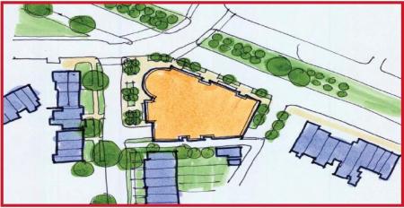
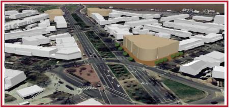
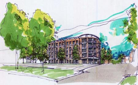
With that in mind, I turn to the draft of the Pennsylvania Avenue SE Land Development Plan.  Of specific interest for this intersection is the Potomac Ave sub-area plan.  This iteration identifies the 1401 Pennsylvania parcell as a key redevelopment opportunity.  A quick glance at the area will quickly identify the SE corner of the square as the weak link, containing a couple of vacant lots, a parking lot, and New York Pizza.  Living in the area, I love what NY Pizza brings to the ‘hood, so I would sure hope that any redevelopment helps them find a new home.  Even so, you can totally tell it used to be a Pizza Hut.

With Jenkins Row filling in the old gap on the eastern edge of the square, this parcel is the one missing link (aside from the Metro station plaza).  As such, the plan calls for new mixed-use construction at the side in the same mold as the Jenkins Row development – first floor retail with office and/or residential above.

Potomac Ave Plan

(Plan view)

Potomac Ave Massing

(Massing perspective)

Potomac Ave Sketch

(Concept sketch)

A couple of points stand out.  First, when combined with the reconfiguration of the intersection’s traffic flow, buildings fronting on the new square ought to see more foot traffic – at a very least, the sidewalks they front on should be far more attractive to pedestrians walking either around the square or passing through it.

Second, the current Metro plaza, as mentioned above, would then be the one missing part of the streetwall enclosing this square.  Given that the station is such a focus for foot traffic, this is fine – but one potential benefit is that a taller structure on the 1401 site is directly in the line of sight of Metro patrons coming out of the station’s escalator well.

All together, such a project could be the keystone in the arch for this public space.  As of right now, I’m unaware of any specific plans for the site.  I’ll just enjoy my pizza until then.

But seriously, if this site does get developed soon, you gotta keep the pizza.