Moving to alexblock.net

November 9, 2009

Apologies for the light posting recently – I’ve been setting up a new domain for the blog over at alexblock.net.

I’m working on a re-direct solution, but for now, please update your bookmarks, permalinks, RSS subscriptions, etc.  All of the content over here is already archived over there.

No free lunches

November 3, 2009

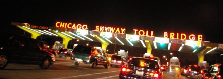
ChicagoSkyway

Photo by Andrew Ciscel

There have been lots of good items on the ICC recently, mostly dealing with the ICC’s proposed tolling scheme.  The City Fix DC looks at the rates:

The answer that’s been in the news lately is tolling. Tolls are planned for the Intercounty Connector (ICC), an 18.8-mile highway under construction between Gaithersburg and Laurel. To cover the road’s $2.56 billion construction cost, the Maryland Transportation Authority’s board has proposed rush-hour tolls of $.25 – $.35 per mile for 2-axle vehicles from 6:00 to 9:00 a.m. and 4:00 to 7:00 p.m. on weekdays.  Off-peak rates for 2-axle vehicles would range from $.20 to $.30 per mile.  The price tag would be around $11 roundtrip for the many drivers expected to use the ICC to commute between I-95 and I-270.  The ICC tolling plan is getting a lot of press for proposing some of the highest rates in the country.

The City Fix notes that “on paper, the argument for road tolling is strong,” but doesn’t really address what kind of roads are being tolled, and at what rates.    The ICC’s basic problem is that the tolls for that road are trying to finance the same road.  Instead of tolling the congested roads around the ICC, using that toll to both manage traffic and raise revenue for more capacity, they’re leaving the congested routes free while tolling the new roads that have very little congestion.

In essence, they’re tolling the wrong road.

This isn’t a new revelation.  In the Baltimore Sun, Michael Dresser says it was always meant to be like this:

Richard Landon of District Heights showed up to testify against any tolling. “We as taxpayers have already paid our share of taxes,” he said.

Actually, we haven’t.

At least, we haven’t paid enough to build a $2.6 billion, six-lane highway through suburban Washington. The toll road vs. freeway issue was decided during the Ehrlich administration with the acquiescence of the General Assembly. Neither wanted to put their necks on the line to raise gas taxes, which haven’t gone up since the early 1990s, to build the road as a freeway. It was either toll road or no road.

No free lunch.

The fact is that very few potential road links have the tolling potential to totally pay for themselves.  Those kinds of roads are the key infrastructure we’ve traditionally paid for with tolls – key bridges and tunnels, for example – but that doesn’t really include second-tier suburban beltway links.  We know this, yet we continue to punt the political football of actually paying for stuff.

This isn’t to say tolling is the wrong idea – it’s the right idea, but being used in the wrong place.  Chris Bradford noted during NYC’s discussion of congestion pricing the stripped-down economic logic of using congestion tolls as a means of measuring demand for more capacity and then financing it:

But congestion pricing does more than relieve congestion.  Congestion pricing tells us when a road needs more capacity.  Additional capacity costs money, and drivers are willing to pay only so much for it.  That “so much” is exactly equal to the price they are willing to pay to avoid congestion. When the revenue collected by congestion pricing is low — too low to finance new capacity — we know we have enough capacity.  Drivers aren’t willing to pay for more, so building it would be wasteful.

On the other hand, If a properly priced road starts generating “too much” revenue — enough to cover the cost of expanding capacity — then it’s time to figure out how to add the capacity users are willing to pay for.

Instead of putting congestion pricing in place on the beltway and then determining if a) demand is there for the ICC and/or HOT lanes (since those lanes represent additional capacity); and b) if toll revenue is sufficient to pay for those expansions, we’ve instead gone ahead and will build the new lanes anyway, under the veneer that we can pay for them with tolls only on the new portions.

This doesn’t just apply to freeways, either.  This works for any congested area.

Viewed properly, then, transit is simply a means for adding capacity.  (Yes, I’m well aware of other arguments for transit, but I’m concentrating on the one that ought to appeal to the economics-inclined.)

The logic of congestion pricing, then, is that the old capacity is supposed to finance the construction and operation of the new capacity.  Or to put it in the charged language that dominates transit debates, the old capacity is supposed to subsidize the new capacity.  Indeed, if users had to pay “cost” for the new capacity, then too few would switch from the old road.  That makes no sense because it creates the wrong incentives.

This does not mean the new capacity — whether road or transit — should be free.  It should be congestion-priced, too.  And as time goes by, the revenue raised thereby might cover the cost of operation and, in turn, finance even more capacity.  But until that transpires, we shouldn’t insist that new capacity pay for itself.

Bold is mine.  Insisting and expecting that we can get something for nothing because it will “pay for itself” isn’t a real solution.  Road tolling programs need to be able to toll roads that are currently free to users, and they need to approach the issue through the lens of the entire transportation system.

Parking on display

November 2, 2009

“Follow the money…”

The National Building Museum‘s newest exhibition is open for business – a brief history of parking structures.  The exhibit has a great collection of archival photos and other items, looking at the evolution of parking structures through time – from elaborate, full-service garages to self-parking decks to LEED certified garages that attempt to make parking a car sustainable in some fashion.  Likewise, the exhibit delves into the social role of the parking structure – with a clip of prominent movie scenes from parking garages (meeting with Deep Throat, getting cool, and getting lost, amongst others) as well as the raw aesthetics of these structures.

What’s missing, however, is any discussion of why parking is necessary.

Philip Kennicott, the Washington Post‘s architecture critic, has a review of the exhibition in this Sunday’s paper.  He notes the fact that the need to park is taken at face value, without question:

The Building Museum’s fascinating and comprehensive “House of Cars” exhibition takes parking for granted, and from that assumption tries to cover the subject dispassionately. It proves that parking structures needn’t be ugly, that they were once more routinely beautiful and integrated into the urban fabric, and that even today they can be architecturally daring if real architects are allowed to explore the poetry of the structure.

The interesting juxtaposition, however, was the exhibit that assumes the need for parking opened just as the story of DC USA’s woefully underutilized parking garage was in the news.

Kennicott also notes another missing piece of the discussion – price.  Perhaps this shouldn’t be surprising.  Given that the exhibit starts from the position that demand is there for parking no matter what, a discussion of supply, demand, and price would be a bit much.  The very idea that we might not need that parking after all never crosses the minds of those designing these structures, at least not as they’re presented to a patron walking through the galleries.  Kennicott notes the disconnect:

But the future isn’t all bright for the National Parking Association. Away from the exhibition hall, with its free-flowing red wine and mini-burgers, participants gathered to hear lawyer and lobbyist Vincent Petraro describe how he helped keep at bay a New York proposal to institute “congestion pricing” in the gridlocked south end of Manhattan. This new user fee would charge drivers entering the zone from 6 a.m. to 6 p.m. Proponents hope it will clear up the streets, clean up the air and generate revenue. Petraro worries that it will hurt business. He cites London, which instituted a similar plan in 2003.

“Yeah it worked, if you want to create a ghost town,” Petraro says of a city that at last check was anything but a ghost town.

Congestion pricing, says Prof. Donald Shoup of UCLA, could hurt the bottom line for parking lot owners. The power of that bottom line was obvious throughout the Parking Show of Shows, where even bright signs — environmentally sustainable lighting and other improvements to design — were predicated on their cost savings. But Shoup, who studies the economics of parking, is interested in a different, more civic-oriented bottom line. He argues that parking is yet one more element of the basic American infrastructure that hasn’t been subjected to the basic rules of the market. Cities all too often under-price their parking meters, which explains why drivers tie up traffic cruising for a cheap space. And for decades cities have required developers to include parking as part of new construction, which hides the real cost — economic and environmental — of parking.

Perhaps there was a more literal message to draw from the Bob Woodward’s meeting with Deep Throat in that parking garage – “follow the money.”

Parking is simply a terminal for auto transportation.  All modes of transport have three basic elements – vehicles (airplanes, trains, cars), rights of way (the sky, tracks, roads), and terminals (airports, train stations, parking spaces).  Even a narrow focus solely on parking spaces can be misleading, to say nothing about simply writing off all other modes of transport.  Transportation, by nature, is multi-modal.  The reality of our urban environments is more complex than a pretty parking garage.

Which brings us to Columbia Heights, and yet another parking boondoggle. But this may also be the future of parking: Less is more. Most of the larger discussion of parking, including the dialogue at the National Parking Association and to a somewhat disturbing extent in the National Building Museum exhibition, is predicated on the idea that parking is a necessity. That it can be improved, but not eliminated. Even the act of studying parking as an evolving architectural form all too often seems to legitimize that form. But the emptiness of that lot in Columbia Heights, and the nightmare images on display at the “House of Cars” show, suggest that we may not be nearly as addicted to parking as we once believed.

Indeed.  However, despite the exhibit’s conceptual shortcomings, it’s definitely worth a visit.  As narrow as the focus may be, it’s still a fascinating subject – and the National Building Museum’s exhibit design, per usual, does not disappoint.

Transit Expansion

October 28, 2009

Photo by matthewbradley

Streetcars

We’ve got more details on DC’s streetcar plans.  BeyondDC has more details on the plans (at BDC/GGW), and Yonah Freemark chimes in with comments at the transport politic.

And, just for fun, this is a great reason to link to the old map of DC’s streetcar system circa 1958 (matching many of DDOT’s historical photos).

Metro Extensions

In other transit expansion news, Prince George’s County is working on re-doing their transportation plan.  One of the ideas thrown out so far is an extension of the Green Line from Greenbelt through to Laurel:

The county also wants the Green Line extended from Greenbelt to Fort Meade by way of Beltsville and Laurel. The stops could include Konterra, a massive mixed-use development underway at the eastern end of the ICC.

GGW’s summary on these developments also links back to previous posts on the plan’s highway and transit components.  Dave Murphy, however, takes the Green Line extension idea and improves upon it – by diverting the Metro extension away from the CSX/MARC Camden line tracks though Fort Meade (which is already a huge employment center and set to grow even more with various BRAC relocations) before terminating at Odenton – also connecting with the MARC Penn Line.
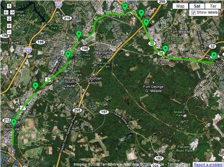
GreenLineExtMap

The idea of serving Fort Meade is good – it needs more transit service to meet growing demand.  Likewise, the idea of connecting both MARC lines together through Fort Meade is also good.  The problem, however, is that Metro isn’t the best tool to accomplish this task.  It’s the most expensive mode of transit we have in this region – and should be reserved for the highest capacity, highest potential routes.

The desire to extend Metro rather than invest in other modes is understandable – everyone wants the best.  However, in this case, a massive upgrade of MARC service would be more appropriate and cost-effective – expanding service days and hours, increasing frequencies, offering through-routing to Virginia, and so on.  This site has the advantage of MARC lines on both sides.  If service levels could be increased to match those on some of the Metro-North commuter lines (10-20 minute peak hour headways, late night service, weekend service), extending the Metro wouldn’t be needed.  In the comments of the GGW article, BeyondDC provides an alternate proposal – increasing MARC service while building a cross-“town” light rail line to provide service through Fort Meade.

These kinds of ideas, whether they’re fantasy maps or some other proposal, always generate a lot of interest.  Matt Yglesias offers his thoughts:

Here I think the key thing to keep in mind is that when you’re talking about new heavy rail construction, the potential benefits can be quite large but you have to decide if you actually want to seize them.

If you added a Metro station there, would the local area permit the surrounding quarter mile or so developed as a fairly dense walkable community? Or would people hear about proposals to build on the green space and up-zone the built-up area and decide that would lead to too much traffic? Maybe instead they’ll want to just turn the undeveloped patch into another parking lot. That’d be no good. And the existing land use patterns around Maryland’s Green Line stations don’t inspire a ton of confidence.

Of course, it’s much easier to create an urban environment in an urban setting – plus, you can create the same kind of TOD/urbanism with a heavily accentuated MARC service.

Ryan Avent also chimes in at The Bellows:

To expand on this a little bit, Metro is the region’s most expensive transit option, but it’s also the one with the greatest potential to drive development. Generally speaking, we want to plan our transit systems so that we’re maximizing the benefits we get for the cost of the investment. If Maryland isn’t prepared to zone for significant development around Metro stations, it would be very silly to make the large investment in Metro. Better to develop a commuter rail line or light rail line or both (depending on anticipated development and commuting patterns).

Metro can indeed help shape development, but it’s important to realize that Laurel is still Laurel – no matter how you slice it, it’s a long ways away from downtown DC.

The Silver Line, to take another example, is an expensive investment. It would probably have been much smarter to simply connect Fairfax County destinations (and Dulles) with Arlington and the District via commuter rail but for the fact that the new Metro line is part of a major effort to increase density at Tysons corner.

The key difference between a Green line extension and the Silver line, however, is that the Green line already parallels an existing transitway with huge potential to upgrade service on the cheap (relatively speaking).  The Silver line doesn’t have a similar option – Commuter Rail beyond Tysons Corner would indeed be a great option in the abstract, but the conditions don’t exist to make it work.

Avent’s conclusion is spot on, however.  Extending Metro further out along the Green line is a mis-match between location and mode, and these kinds of mis-matches will impose costs on the core.  Instead of a Parisian system where the Metro and RER compliment each other, Metro’s hybrid nature pushes these two uses into the same system.

These costs are increasingly borne by users in the core of the system, where growth in the number of trains and passengers have led to crowded conditions on platforms and back-ups during peak periods. To some extent, this can be addressed by increasing peak fares, but given the obvious value of Metro, the growth in the system’s spokes, and the fact that the District is better suited than almost anywhere else in the metro area to handle increased density, it seems clear that new core capacity is needed (as well as a new river crossing over or under the Potomac).

Metro doesn’t stop running when it enters the District. If Virginia and Maryland want to continue to build Metro extensions, they ought to offer their full support to an effort to add capacity in the core.

What’s more – investments in the core (say, in the form of a new, separated Blue line) will bear fruit for lines outside the core as well.  The new Blue line would eliminate the capacity constraints of the interlined portion of track through DC – thus increasing the potential capacity on existing Orange and Blue line track in MD and VA.
Transit Series

October 28, 2009

Image from wallyg on Flickr

No, it’s not a Subway Series.  But really, I didn’t need any motivation to root against the Yankees.  Now, the Phillies are just begging me to hop on the bandwagon:

I have no idea what it costs to charter an Amtrak train, but I love the idea.  As I excitedly noted yesterday the World Series is coming and it’s a pure Northeast thriller with the Philadelphia Phillies taking on the New York Yankees.  Apparently the Phillies chartered a train from Philadelphia to get to New York.

Evoking a bygone era when rail travel was the main mode of transportation in baseball, the Philadelphia Phillies rolled into Penn Station on a chartered train about 6:03 p.m. Monday, but they were not looking to the past century for inspiration.

The Phillies previously took the train to the World Series in 1950, when they were swept by the Yankees. But that dreary omen did not deter the defending champion Phillies from using the same mode of transportation that Philadelphia’s Whiz Kids took 59 years ago.

The reason for the train was neither historical novelty nor an exercise in team building in advance of the World Series, which begins Wednesday at Yankee Stadium. It was pure convenience. The distance between Philadelphia and New York is too short for a flight, and a fleet of buses traveling up the New Jersey Turnpike could spend as much time on the approach to the Lincoln Tunnel as the entire train ride.

The only shame about this trip is that the Phillies got the pleasure of starting in the glory of Philadelphia’s 30th Street Station but had to end their trip in the travesty that is New York’s New Penn Station

The NYT‘s baseball blog also looks into traveling between the two stadiums using nothing but local transit serivces:

But as seasoned frugal travelers between Philadelphia and New York know, you would not have to take Amtrak at all to get from stadium to stadium. A fan leaving Citizens Bank Park around 2 p.m. Monday could have gotten to Yankee Stadium for less than $25 in less than four hours.1. Take the Broad Street subway from Pattison Station to City Hall, and transfer to the Market Frankford Line and exit at 30th Street Station: $2, 28 minutes.

2. Take the 2:37 p.m. R7 Septa train from 30th Street Station to Trenton, arriving at 3:25: $8, 48 minutes.

3. Take the 3:40 New Jersey Transit train from Trenton to New York Penn Station, arriving at 5:08 p.m.: $12.50, 1 hour 28 minutes.

4. Exit Penn Station, walk to Sixth Avenue, take the D train to Yankee Stadium: $2.25, 37 minutes.

Total cost: $24.75.

Total travel time: 3 hours 42 minutes.

Nice.

ACS – Answering my own question

October 27, 2009

(hat tip to Dr. Gridlock)

In earlier posts, I wondered what DC’s regional transit data looks like – and with the release of the 2006-2008 three-year estimates from the American Community Survey, we have some answers.

Data is available for the Washington, DC urbanized area.  That area looks like this:

So, that includes a lot of stuff, and a whole lot of suburbia.

The transportation data is as follows:

COMMUTING TO WORK
Workers 16 years and over 2,221,629 +/-8,331 2,221,629 (X)
Car, truck, or van — drove alone 1,415,834 +/-9,036 63.7% +/-0.3
Car, truck, or van — carpooled 237,724 +/-5,008 10.7% +/-0.2
Public transportation (excluding taxicab) 363,334 +/-5,319 16.4% +/-0.2
Walked 77,067 +/-2,795 3.5% +/-0.1
Other means 33,023 +/-1,979 1.5% +/-0.1
Worked at home 94,647 +/-3,018 4.3% +/-0.1

So, 63.7% of the region’s workers commute in a single-occupant vehicle, with 16.4% using transit.  For the same three year window (2006-2008), DC’s stats look like this:

COMMUTING TO WORK
Workers 16 years and over 293,532 +/-3,568 293,532 (X)
Car, truck, or van — drove alone 108,373 +/-3,363 36.9% +/-1.0
Car, truck, or van — carpooled 19,121 +/-1,591 6.5% +/-0.5
Public transportation (excluding taxicab) 108,687 +/-2,469 37.0% +/-0.8
Walked 34,455 +/-2,033 11.7% +/-0.7
Other means 9,421 +/-1,023 3.2% +/-0.3
Worked at home 13,475 +/-1,451 4.6% +/-0.5

36.9% drove alone, while 37.0% used transit.

Note that this is the rolling three-year sample, so the data is slightly different from the 2008 ACS data released earlier.

This Week – Ice Hockey!

October 26, 2009

DDOT’s streetcar website has a lot of great resources.  All the things you’d expect, like open house dates, construction updates, their new plans and other documents, are there and easily accessed.

They also have a gallery of some great old photos of DC’s original streetcar network.

This image (circa 1943), from the old underground turnaround terminus for the southern end of the 14th line features a nice vintage advertisement for upcoming hockey games at Uline Arena.  Looks like Hershey and Cleveland will be in town to play the Washington Lions.   Hershey, of course, is now the AHL farm team for the Caps.

More photos:

Georgetown

Pennsylvania Ave, looking at the Treasury Building, circa 1925.

DDOT’s got a whole slew of historical photos in their online archive, well worth checking out.

Looking north up Connecticut Ave towards Dupont Circle, 1958.  Note the two underpass entrances – the nearest for streetcars and the other (currently extant) for cars.

Another from 1958, this is what’s now Freedom Plaza.

Feedback loops

October 25, 2009

The Tsarchitect succinctly summarizes the various discussions on McMillan Two.  As noted in my thoughts on the plan, this kind of dialogue is vital to make this a better plan.

  • JD Hammond offers a counter-proposal, drawing on Asian cities and how they interface with their rivers.
  • Dave Murphy notes the opportunity/challenge this plan presents for the BRAC process, as it involves re-use of a lot of land controlled by the Military.
  • GGW summarizes DDOT’s newest iteration of the streetcar plan, making the comment rounds now.

With regard to the McMillan Two focus area of the Anacostia, the streetcar plan raises a couple of interesting points.  The plan features a Minnesota Avenue line, which would parallel a great deal of the river while still running through established neighborhoods.  As mentioned in the GGW summary, Ward 6 Councilmember Tommy Wells suggested moving the N-S link through Capitol Hill further to the east, in order to better serve the planned Reservation 13/DC General development – a path that would also serve more of the proposed plan area, through both Reservation 13 and the RFK Stadium site. Such a line shouldn’t replace the 8th Street line, but it would be a nice compliment to it.

An interesting connection that’s not on the map is through Buzzard Point.  The plan features two lines terminating on Buzzard Point, near Fort McNair.  The obvious and interesting connection would be to extend tracks south across a new South Capitol Street Bridge, which would give you cross-river connectivity with multiple modes and via multiple routes.

Such a density of network connections is a great starting point to enable the kind of development needed to fill this plan with buildings.   It’s not quite DC’s version of the DLR, but it’s a start.

Visualizing DC’s commute

October 24, 2009

Matt Yglesias cites a great infographic from Wikipedia on national commuting mode splits.  The data, from the American Community Survey, again is only for work commutes for those residing within the central jurisdiction listed.  This is a nice visual representation to see how DC stacks up nation-wide.

Since DC’s geographic area is small, both the population and corresponding bubble for the number of workers will be smaller than other cities.  Hence, Boston (population: 609k) and San Francisco (pop: 808k) have similarly sized bubbles to DC.  I’d love to see this same graph for metropolitan areas rather than just core cities, since metropolitan areas are a far more realistic representation of the functional unit of cities.

Nevertheless, given the jurisdictional limitations of the data, it’s interesting to see all the cities represented.  Looking at the data in list form, it’s clear that DC is second to New York in a number of areas, but this graph shows how big that gap is – as well as three tiers of cities.  New York is in a class of their own, followed by a group of transit-oriented cities (DC, Boston, Philly, SF, Chicago, Baltimore, Seattle), and then everyone else.

End of the race

October 19, 2009

Team Ontario/BC’s house.

Ruthless efficiency:

The Solar Decathlon is over, and zee Germans have won.  DCist has photos here, and DC Metrocentric has a few observations:

This year, it was evident that most of the houses were designed with mainstream marketability in mind. Most of the houses were designed around a contemporary aesthetic and open plan arrangement, while others like the University of Illinois Urbana-Champaign and University of Louisiana Lafayette referred to localized American Vernacular styles. The forms of the houses were primarily long thin rectangles, some had courts, while others had breezeways, but in total they were designed according to market standards for handicap accessibility and for mass production. This plan of public accessibility and marketability was definitely working. The grounds were extremely crowded and the lines to enter the winning houses wound down the main walk. Inside, the houses were obviously over maximum occupancy, and the crowds were really excited by what they saw. I overheard endless questions about fixtures and furniture from the most unlikely guests.

Also, one thing I hadn’t noticed – following on discussions of green infrastructure and urban hydrology:

What was the most striking in the engineering field was not what the teams did, but what they weren’t allowed to do, which was re-use gray water (waste water from non-sanitary means) or rainwater within the dwelling. Many of the houses had been designed with systems to reuse water, but the DC plumbing code forbids the use of gray or rain water for any domestic purpose except landscaping. Apparently, in many jurisdictions across the country using any water besides well water or municipal water for domestic uses is prohibited. The students at many of the houses made it a point to tell the crowds about their water reduction features and the specific reason why they couldn’t use it and encouraged people to contact their representatives to change this ordinance.

Water reduction is certainly an admirable goal, but it’s also one of those features that’s going to matter much more in some geographies than others.  All the more reason for codes (enacted at the local level) to take their local context into consideration.

The other thing Lepler notes above is the popularity of the Decathlon.  I stopped by several times, each visit clogged by people waiting in long lines to stand in small, crowded houses.  This level of engagement seemed both genuine and tangible – people could envision themselves living in these places, in spaces of this size, etc.

Elsewhere…

NIMBYs under the microscope:

Ryan Avent’s found scientific discussions of NIMBYism.

Available here. This is the abstract:

This paper suggests a cause of low density in urban development or urban sprawl that has not been given much attention in the literature. There have been a number of arguments put forward for market failures that may account for urban sprawl, including incomplete pricing of infrstructure, environmental externalities, and unpriced congestion. The problem analyzed here is that urban growth creates benefits for an entire urban area, but the costs of growth are borne by individual neighborhoods. An externality problem arises because existing residents perceive the costs associated with the new residents locating in their neighborhoods, but not the full benefits of new entrants which accrue to the city as a whole. The result is that existing residents have an incentive to block new residents to their neighborhoods, resulting in cities that are less dense than is optimal, or too sprawling. The paper models several different types of urban growth, and examines the optimal and local choice outcomes under each type. In the first model, population growth is endogenous and the physical limits of the city are fixed. The second model examines the case in which population growth in the region is given, but the city boundary is allowed to vary. We show that in both cases the city will tend to be larger and less dense than is optimal. In each, we examine the sensitivity of the model to the number of neighborhoods and to the size of infrastructure and transportation costs. Finally, we examine optimal subsidies and see how they compare to current policies such as impact fees on new development.

Bold is mine.

Along those same lines…

Mammoth links to an article in the Wall Street Journal by Thomas Sugrue. Sugrue notes the problems of the ownership society and defining the American Dream in terms of homeownership – noting that renting is a far more prudent decision in many cases.

Yet the story of how the dream became a reality is not one of independence, self-sufficiency, and entrepreneurial pluck. It’s not the story of the inexorable march of the free market. It’s a different kind of American story, of government, financial regulation, and taxation.

We are a nation of homeowners and home-speculators because of Uncle Sam.

I’ve had the pleasure of listening to Sugure speak on many items (including the state of Detroit), and this article doesn’t disappoint.  Mammoth notes the cultural aspects of sprawl, complimenting the economic analysis:

I tend to focus on technological (automobile), infrastructural (the interstate system, the regulatory dictatorship of the fire engine and its turning radii) and political (tax policies that favor home ownership, strict single-use zoning) reasons for the development of the form and ubiquity of the American suburb, but it is also very interesting to consider the suburb as the outgrowth of a cultural ideal, of a particular understanding of the relationship between person and home, or to consider the financial crisis as the (il)logical conclusion of that ideal, cultivated to absurd proportion and applied without regard to circumstance. That ideal is so deeply embedded in our culture that it is nearly invisible, seeming not a cultural construction but an essential and timeless rule, as deeply-embedded ideals often do.

As we re-examine the cultural underpinnings of the American Dream, we ought to re-examine the policies that biased that dream into suburban form and ask how we can give walkable, transit-oriented places a fair shake.